Schilthorn - Birg - Grauseeli - Rotstockhutte - MurrenWalk 8101
Canton - Bern / Berne - Jungfrau Region
Author - Hotel Alpenblik Mürren
Length - 13.0 km / 8.1 miles
Ascent - 150 metres / 495 feet
Descent - 1400 metres / 4620 feet
Time - 4.00 hours
Grade - moderate
Click image to visit gallery image.
This is a high mountain walk and is suitable for walkers with experience. The route starts at the summit of the Schilthorn (2970 m.) and descends (using a very interesting route) to the traffic free village Mürren situated high above the Lauterbrunnen valley.
Start - the mountain station of the Schilthorn Cablecar. There are two ways of reaching the cablecar from Lauterbrunnen. Either (1) take the Post Bus to Stechelberg and board the cablecar at the valley station or (2) take the cablecar and train to Mürren and board the cablecar at the midway station. See Transport Map for the Jungfrau Region.
End - the railway station in Mürren where regular trains take you back to Grütschalp with connections to Lauterbrunnen.
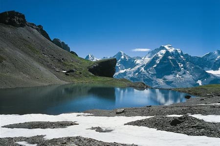
From the summit of the Schilthorn descend east to Birg. Ignore any paths descending to Grauseeli on this section of the route. Birg (2677 m.) is a satellite summit to the Schilthorn and offers exceptional views east towards the Eiger, Mönch and Jungfrau with the village of Mürren far below.
Leave the summit of Birg using the same path as on the approach and descend to the col (2599 m.) and a junction of paths. Turn left and descend to the Grauseeli. Continue to descend into the Schiltal losing height quickly. After a short way turn right for Wasenegg, maintaining similar height across the east side of the Schilthorn.
Climbing slight you reach the top of the Wasenegg, a well-defined ridge running east. Ignore the ridge path and instead descend south. Reaching a transverse path turn left for the Rotstockhütte with its fine views and good food.
Retrace your steps and follow the clear path that follows a line parallel to the Wasenegg ridge in the direction of Speilbodenalp. After approximately two kilometres the path descends steeply over the crags at the eastern of the Wasenegg ridge to reach Speilbodenalp. From here it is an easy walk through pleasant meadows to Mürren.
Suggested Maps
 Landeskarte der Schweiz - 1:50000 - Sheet SW 5004 - Berner Oberland
Landeskarte der Schweiz - 1:25000 - Sheet SW 2520 - Jungfrau Region
Wanderkarte - Wengen, Mürren & Lauterbrunnental - 1:40000
Recommended Books
Tour of the Jungfrau Region
 A guidebook to the Tour of the Jungfrau Region, a 111km trek from Schynige Platte to Wilderswil in 9-12 days through the Bernese Oberland under the Mönch, Eiger and Jungfrau, exploring both well-known and hidden valleys, surrounded by soaring peaks, glaciers, lakes and ridges. A good first Alpine trek with plenty of bad-weather alternatives.
The Tour of the Bernina
 Guidebook describing a 9-stage (119km) route around the Piz Bernina massif in the Alps on the Swiss-Italian border near St Moritz, and the 8-stage (94km) Alta Via Valmalenco exploring the Valmalenco valley, in the shadow of Monte Disgrazia. The Tour of the Bernina is suitable for first-time trekkers but the Alta Via needs some experience.
Stay Safe
Do enjoy yourself when out walking and choose a route that is within your capabilities especially with regard to navigation.
Do turn back if the weather deteriorates especially in winter or when visibility is poor.
Do wear the right clothing for the anticipated weather conditions. If the weather is likely to change for the worse make sure you have enough extra clothing in your pack.
Do tell someone where you are planning to walk especially in areas that see few other walkers.
Do take maps and other navigational aids. Do not rely on mobile devices in areas where reception is poor. Take spare batteries especially in cold weather.
Do check the weather forecast before leaving.
Do do not exceed your capabilities.
Please Note - These walks have been published for use by site visitors on the understanding that Walking Sitzerland is not held responsible for the safety or well being of those following the routes as described. It is worth reiterating the point that you should embark on a walk with the correct maps at the most detailed scale where possible. This will enable any difficulties with route finding to be assessed, and corrective action taken if necessary.