Stechelberg - Obersteinberg - OberhornseeWalk 8109
Canton - Bern / Berne - Jungfrau Region
Author - Hotel Silberhorn Lauterbrunnen
Ascent - 1155 metres / 3812 feet
Descent - 1155 metres / 3812 feet
Time - 6.00 hours
Grade - moderate/hard
Click image to visit gallery image.
Mountain trail from Trachsellauenen. Ascent into the marvellous alpine area of the upper Lauterbrunnen valley which has been under protection since 1960. An extremely rewarding hike as far as scenery and botany are concerned. No asphalt.
Start & End - Stechelberg - reached by Postbus from Lauterbrunnen where there are rail connections to Wengen, Grindelwald and Interlaken. See Transport Map for the Jungfrau Region.
| Route | Altitude | Time (Out) | Time (Back) |
| Stechelberg | 910 metres | 0 h 00 min | 2 h 40 min |
| Trachsellauenen | 1203 metres | 0 h 50 min | 2 h 00 min |
| Ammerten | 1470 metres | 1 h 30 min | 1 h 30 min |
| Obersteinberg | 1774 metres | 2 h 30 min | 0 h 45 min |
| Oberhornsee | 2065 metres | 3 h 30 min | 0h 00 min |
At the Hotel Stechelberg (Post bus terminal) we head straight at the end of the valley road on a little narrow road. Below the hamlet of Sichellauenen we cross over onto the other side of the Schmadri Lütschine, whose bubbling accompanies us without fail. Through mountain forests and across lower alps we continue to hike in varying ascent towards Trachsellauenen. At the fork behind the mountain hostel we keep right; 500 meters further into the valley, at the signpost "Bergwerk", 1260 meters, the bumpy road turns into a hiking trail and mule track.
The indication "Bergwerk" (= mine) on the signpost recalls the time 300 years ago, when iron and lead ore were mined here. Timber from the valley forest was used to heat the smelting furnaces while today the forest is threatened by foehn (a hot air current), avalanches, bark beetles and air pollution. We keep right at the signpost just mentioned and ascend 200 meters in the forest. We have a beautiful view when we leave the forest at Ammerten: Schmadribach waterfalls, Breithorn, Tschingelhorn and the rock pinnacles of the Lauterbrunnen-Wetterhorn and the Chanzel face us.
Today Ammerten is a small alp, but it was once a mountain village inhabited year round by Walser emigrants from the Lötschental one the other side the mountains. Across the Wetterlücke, the saddle between the Breithorn and the Tschingelhorn, the inhabitants of Ammerten and other Walser settlements in the upper Lauterbrunnental such as Gimmelwald and Sichellauenen had contacts with the Lötschental for decades. Those contacts were broken off later because of the Reformation separating catholics Valais people from reformed Bernese subjects and the increasing glaciation in the pass area.
We continue ascending steeply across grazing grounds towards the Hotel Tschingelhorn. Shortly afterwards we cross a steep avalanche trail, the Schluchgraben, heading into the valley. Climbing moderately we approach the hotel at the Obersteinberg. The trail winds afterwards in a slight up and down for a kilometer into the valley towards the bridge across the Tschingel Lütschine.
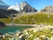
We start climbing slightly again: on both sides of the trail we see slopes of moraines studded with many different kinds of plants and rocks with scratches of the glaciers. On the right-hand side mighty faces tower above us, 1000 meters up to the Ellstabhorn and the Tschingelgrat. The last bit of the trail to the Oberhornsee is rather steep once again. The Oberhornsee is rather small compared with other mountain lakes in the Bernese Oberland. But the surroundings of the little lake hedged in by moraines is of incomparable beauty.
Suggested Maps
 Landeskarte der Schweiz - 1:50000 - Sheet SW 5004 - Berner Oberland
Landeskarte der Schweiz - 1:25000 - Sheet SW 2520 - Jungfrau Region
Wanderkarte - Wengen, Mürren & Lauterbrunnental - 1:40000
Recommended Books
The Tour of the Bernina
 Guidebook describing a 9-stage (119km) route around the Piz Bernina massif in the Alps on the Swiss-Italian border near St Moritz, and the 8-stage (94km) Alta Via Valmalenco exploring the Valmalenco valley, in the shadow of Monte Disgrazia. The Tour of the Bernina is suitable for first-time trekkers but the Alta Via needs some experience.
Walking in the Alps
 An outstanding and comprehensive book exploring the walking and trekking possibilities in every Alpine region. Many thousands of possible routes are suggested, from the Maritime Alps of southern France throughout the range to the Julian Alps of Slovenia. Walks vary from undemanding to long and tough, and everything in between.
Stay Safe
Do enjoy yourself when out walking and choose a route that is within your capabilities especially with regard to navigation.
Do turn back if the weather deteriorates especially in winter or when visibility is poor.
Do wear the right clothing for the anticipated weather conditions. If the weather is likely to change for the worse make sure you have enough extra clothing in your pack.
Do tell someone where you are planning to walk especially in areas that see few other walkers.
Do take maps and other navigational aids. Do not rely on mobile devices in areas where reception is poor. Take spare batteries especially in cold weather.
Do check the weather forecast before leaving.
Do do not exceed your capabilities.
Please Note - These walks have been published for use by site visitors on the understanding that Walking Sitzerland is not held responsible for the safety or well being of those following the routes as described. It is worth reiterating the point that you should embark on a walk with the correct maps at the most detailed scale where possible. This will enable any difficulties with route finding to be assessed, and corrective action taken if necessary.