Sunnegga Paradise - Fluhalp - ZermattWalk 8112
Canton - Valais / Wallis - Zermatt & the Mattertal
Author - Anna & Mark Bradley
Length - 13.0 km / 8.1 miles
Ascent - 420 metres / 1386 feet
Descent - 1000 metres / 3300 feet
Time - 6.00 hours
Grade - moderate
Click image to visit gallery of 6 images.
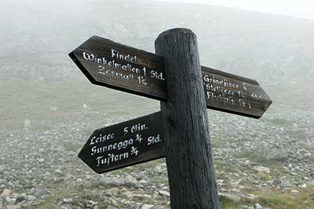
There are a whole host of walks in this area starting from Sunnegga. All are clearly signed. Take the underground funicular from Zermatt to Sunnegga paradise. From here there are some fine panoramic views of Zermatt and the valley as well the mountains that surround the town.
Follow the signs to Leisee. In just a few minutes you will reach this lake with the well-known reflections of the Matterhorn. Continue to Stellisee and Fluhalp via Grindjesee looking out for sheep, goats and marmots on the way. Reaching the high and extensive morraines of the Findel glacier marks the start of the return to Zermatt.
The descent to Zermatt can be made via Grüensee, on the other side of the valley, and Findeln with its pretty barns, with the final section coming down through pine forest. The walk took just over 6 hours altogether with lots of stops for photos etc. It's a long, if not difficult, walk.
Suggested Maps
 Landeskarte der Schweiz - 1:50000 - Sheet SW 5006 - Matterhorn/Mischabel
Recommended Books
Tour of the Matterhorn
 A guide to the 145km Tour of the Matterhorn, described anti-clockwise from Zermatt and visits 6 valleys via Zinal, Arolla and Breuil, offering spectacular views of 25 peaks of over 4000m. The route also links up with the Chamonix to Zermatt walkers' Haute Route and the Tour of Monte Rosa. Includes two glacier crossings and takes 8 to 10 days.
Tour of Monte Rosa
 A guidebook to walking the The Tour of Monte Rosa, a 9-10 day, 134km trek circling Monte Rosa anti-clockwise from Zermatt. The high route hugs glaciers and has views of over ten 4000ers. All essential information is provided, including outline maps, route profiles, advice on glacier crossing and accommodation.
Stay Safe
Do enjoy yourself when out walking and choose a route that is within your capabilities especially with regard to navigation.
Do turn back if the weather deteriorates especially in winter or when visibility is poor.
Do wear the right clothing for the anticipated weather conditions. If the weather is likely to change for the worse make sure you have enough extra clothing in your pack.
Do tell someone where you are planning to walk especially in areas that see few other walkers.
Do take maps and other navigational aids. Do not rely on mobile devices in areas where reception is poor. Take spare batteries especially in cold weather.
Do check the weather forecast before leaving.
Do do not exceed your capabilities.
Please Note - These walks have been published for use by site visitors on the understanding that Walking Sitzerland is not held responsible for the safety or well being of those following the routes as described. It is worth reiterating the point that you should embark on a walk with the correct maps at the most detailed scale where possible. This will enable any difficulties with route finding to be assessed, and corrective action taken if necessary.